- ・English
- ・Korean
- ・Chines
- ホーム
- オーストラリアの恐竜
- 恐竜百科辞典644種
- 恐竜序章
- 恐竜系図
- Australia発掘公表メモ
- ニュース
- 年代表
- 大陸の移動
- 世界最大の地底海
- エロマンガ海
 世界最大の足跡化石
- 恐竜探索記
- なんでも実験室
- 無料電子図書
- 化石コレクション
- リンク集
以下の言語でも御覧になれます。
メニュー


世界最大の地底海
The Great Artesian Basin
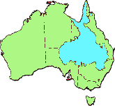
オーストラリアにはクイーンズランド州を中心にニューサウスウエールズ州、南オーストラリア州、更にノーザンテリトリーにまたがる
世界最大の地底海
が、あります。
◎水量は87億メガリットル(メガリットル=100万リットル)もあります。
図の中で青い部分が地底海の位置を表しています。
The Great Artesian Basin
大鑽井盆地は、世界に有る地下水盆地の中でも最大の地底海です。地底海はオーストラリア国土の約5分の1の面積にあたり、クイーンズランド、ニューサウスウェールズ州、南オーストラリア州とノーザンテリトリーの大分水山脈からエア湖までの乾燥、半乾燥地域に及びます。総面積は171.1万平方キロメートル。推定総貯水は87億 メガリットル。 ( メガリットルは100万リットル。オリンピックスイミングプールの約半分に相当する。)
The Great Artesian Basin was formed between 100 and 250 million years ago and consists of alternating layers of waterbearing (permeable) sandstone aquifers and non-waterbearing (impermeable) siltstones and mudstones. The thickness of this sequence varies from less than 100 metres on the Basin extremities to over 3000 metres in the deeper parts of the Basin. Individual bore depths vary up to 2000 metres with the average being 500 metres. Some of the sandstone sequences contain oil and gas where conditions are suitable.
1.Formation
The sandstones from which the artesian water flows were deposited as sediments into three large depressions: the Carpentaria Basin, the Eromanga Basin and the Surat Basin, which together form the Great Artesian Basin.
Over 195 million years ago, at the end of the Triassic period, uplift on the margins of these basins occurred anderosion of these areas led to the formation of the sediments. Throughout the Jurassic period, streams and rivers deposited sand and gravel, and clays and clayey sands were laid down by floodplains and lakes. This process produced a profile of alternating layers. As rivers eroded the steeper slopes, the land began to flatten, and deposition in lakes and large floodplains became more dominant. The sandy sediments consolidated to form the permeable sandstone aquifers from which the artesian water is now tapped and the clayey sediments became the impermeable layers.
Groundwater in the Basin flows generally westward to the south-west over most of the Basin but to the north-west and north in the northern section. The rate at which water flows through the sandstones varies between one and five metres per year. Recharge by infiltration of rainfall into the outcropping sandstone aquifers occurs mainly along the eastern margins of the Basin, more specifically along the western slopes of the Great Dividing Range. Natural discharge occurs mainly from mound springs in the south-western area. Mound springs are natural outlets of the artesian aquifers from which groundwater flows to the surface. Dating of the artesian waters has given ages of almost 2 million years for the oldest waters, which occur in the south-western area of the Basin. Water quality in the main aquifers is generally good with Total Dissolved Solids (TDS) varying between 500 to 1500 milligrams/litre, although pH may be very high, and high sodium levels make it generally unsuitable for irrigation. Water temperatures vary from 30 degrees C in the shallower areas to over 100 degrees C in the deeper areas.
Many bores initially flowed at rates of over 10 megalitres per day (ML/d). However, the majority of flows are now between 0.01 and 6 ML/d. Total flow from the Basin reached a peak of over 2000 ML/d around 1915, from approximately 1500 bores. Since then, artesian pressure and water discharge rates have declined, while the number of bores has increased. The total flow from the basin during 2000 was in the order of 1500 megalitres per day.
How is artesian water being conserved?
State authorities are working with landholders and the Federal government to conserve artesian water and assure the future of the Great Artesian Basin. Legislation passed in the States from 1910, required that all artesian bores be licensed under various water acts.
Since the 1950s, all new artesian bores have been required to have control valves installed and the water distributed by pipeline rather than open drains. Piping of water from older bores is also encouraged. Not only does piping conserve water, it also improves productivity and management practices, as water can be distributed more widely across a property.
Other benefits of capping and piping bores include:
Pipes can deliver water to parts of the property that previously could not be reached by bore drains
When a number of properties are served by one bore, all properties including the ones at the end are guaranteed water
Water quality in piped systems is as good at the watering point as it is at the bore
Stock weakened by drought are better able to drink from troughs
Spear traps can be installed at watering points so that stock can self muster
A well designed system allows the effective use of the whole property all year round
It is possible to deliver food supplements and medication to stock through drinking water
Piped systems allow the possibility of trapping feral animals and/or livestock at watering points
More effective spelling of paddocks as watering points are turned off
Reduction of feral animal habitat
Reduced maintenance time
Despite a substantial number of bores now being fully controlled with water distributed by pipelines to tanks and troughs, about 80% of the total outflow from the Basin is still wasted because of inefficient water delivery systems.
Research into why bores fail has resulted in higher standards of bore construction. Since the 1930s construction standards have required that an outer string of bore casing be cement grouted to protect it from the surrounding corrosive clays and prevent leakage of water up the outside of the casing. Inter-casing cementing is also required.
The Great Artesian Basin Sustainability Initiative (GABSI) is a jointly funded initiative of the Federal and State governments and pastoral bore owners. GABSI aims to preserve the pressure of the Great Artesian Basin through rehabilitating uncontrolled bores and replacing bore drains with polyethylene pipes, tanks and troughs for livestock water.
2.A BRIEF HISTORY
Fresh water is one of the Earth's most important natural resources and can be stored above or below ground. Water is vital to life and this was obvious to the first European settlers who ventured west of the Great Dividing Range. These early settlers, encouraged by good seasons, brought their sheep and cattle out onto the great rolling plains. They soon learned that inland Australia was a harsh environment where droughts were common.
The inland of Australia is traversed by streams but these rarely flow and have few permanent waterholes. Unpredictable rainfall and high evaporation meant that early dams and earth tanks built to service the growing population and pastoral industry were unreliable. Permanent water supplies were needed to allow livestock to survive on the arid plains and to provide supplies for the growing service towns.
Prior to European settlement, Aborigines used the mound springs of the Great Artesian Basin. Mound springs are natural outlets of the artesian aquifers from which groundwater flows to the surface. Some of these mound springs feature in Aboriginal myths and hold significant spiritual and cultural beliefs of indigenous communities. Mound springs were and still are a valuable resource for the support of wildlife.
Europeans first discovered the artesian groundwater of the Great Artesian Basin in 1878 when a shallow bore sunk near Bourke in New South Wales produced flowing water. Many bores were soon drilled near the margins of the Basin in New South Wales and South Australia. In 1885 the Queensland Government Geologist decided to drill a deep bore at Blackall to try to prove the existence of deep artesian supplies in Queensland and provide reliable water supplies during the drought. However, before the completion of this bore, the first artesian flow in Queensland was obtained near Cunnamulla in 1887.
The number of bores drilled in Queensland increased from 34 to 524 in the ten year period from 1889 to 1899. By 1915 over 1 500 flowing artesian bores had been drilled throughout the Basin. The assurance of a reliable water supply for settlers and their stock meant the development of a valuable sheep and cattle industry. Thousands of kilometres of bore drains were excavated to distribute water around properties, thus allowing sheep and cattle to be raised on the vast Mitchell grass, mulga and spinifex plains. Bore drains are small, open channels that can extend 100km or more.
The water from the Great Artesian Basin continues to be of vital importance to outback regions of Queensland, New South Wales and South Australia. This water is often the only available supply for towns and properties for their domestic and stockwatering requirements. The GAB also supplies water for minor irrigation works, key mining and extractive industries, the petroleum industry, an emerging tourism industry and limited industrial purposes. Sound management of this important natural resource by the present users will ensure that future generations may also benefit from this reliable water source.
3.HOW MUCH WATER DOES THE GREAT ARTESIAN BASIN PROVIDE?
Prior to development in the Basin, it is estimated that, excluding the Carpentaria Basin, 300 megalitres of water entered the aquifers of the Great Artesian Basin in Queensland each day. All of this, plus recharge from other States discharged as surface springs or area diffuse leakage through the ground surface. In this way a natural equilibrium of inflow to outflow was maintained. Artesian water discharged from bores peaked around 1915, when 1 500 bores yielded a total flow of approximately 2 000 megalitres per day.
Water users realised, as long ago as 1891, that yields were dropping significantly and that action was required to protect this vast, hidden asset. The problem was not so much the prospect of running out of water, but that the artesian pressure forcing water to the surface was being reduced. About one-third of all artesian bores which flowed when drilled have now ceased to flow and require pumping equipment to bring the water to the surface.
Outflow from the basin has now dropped to around 1 500 megalitres per day and individual bore pressures have fallen up to 80 metres. However, the rate of decline of both pressure and flow has decreased as the Basin is again approaching equilibrium between recharge and discharge.
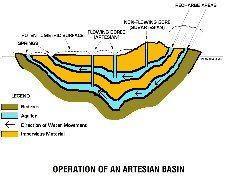
Why an artesian bore flows
"Artesian" water is underground water confined and pressurised within a porous and permeable unit, an aquifer. The aquifers of the Great Artesian Basin consist of permeable sandstones. These aquifers are recharged by rainfall infiltrating into the uplifted and exposed sandstones on the edge of the basin. Recharge waters slowly move down through the sandstone, filling the aquifer to the level of the intake area. As the aquifer is confined by an overlying impermeable unit, the water becomes pressurised. When a bore is drilled into one of the aquifers, the water will rise due to this pressure. The level to which it rises is called the potentiometric surface. If this surface is above ground level, then the bore will flow. In a subartesian bore the water does not rise above the ground surface
How is artesian water being wasted?
Artesian water is easy and inexpensive to utilise, but after it flows to the surface, it is often used inefficiently. In many areas, artesian water is traditionally being allowed to flow uncontrolled from bores into open drains and creeks for stock to drink. Nearly 34 000 km of bore drains are currently in use in Queensland and New South Wales, and individual drains may be in excess of 100 kilometres long. Even in well-maintained drains, up to 95% of the water is wasted through evaporation and seepage.
The use of bore drains for water distribution has many disadvantages and these include:
Infestations of invasive woody weeds, such as prickly acacia, in and around bore drains
Feral animals are provided with a habitat and permanent water supply
Salinity problems can be created or aggravated
Bore drains built across a slope catch run off water, reducing rainfall infiltration below drains and thereby limiting pasture growth
Erosion problems often result from drains overtopping or breaking their banks.
Amount of time and expense needed to maintain bore drains.
Concentration of minerals by evaporation (eg Sodium and Fluoride) can negatively affect animal health.
By controlling bore discharge and replacing bore drains with polyethylene pipes, tanks and troughs for livestock water, these problems will be eliminated.
Some bores, due to faulty construction or the action of corrosive water, have control valves that cannot be turned off, while others have no control valves at all. Much of the water that flows from these bores is therefore wasted, as discharge cannot be restricted to stock requirements.
Some artesian water and some shallow subartesian water is extremely corrosive to steel bore casing. This results in more wastage, as water escapes through the corroded casing and flows out of control over the ground or into other lower-pressure aquifers.
![]()
![]()